| |
Laurel Falls congestion management pilot project begins Sept. 7
August 17, 2021
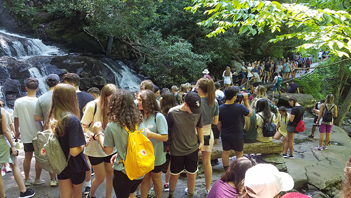
A large group of people congregate at the base of Laurel Falls. Image courtesy of GSMNP |
GATLINBURG – Great Smoky Mountains National Park officials announced that Laurel Falls Trail parking will be available by reservation only from Sept. 7 through Oct. 3, 2021 as part of the Laurel Falls Congestion Management Pilot Project. The pilot project aims to improve visitor safety, relieve congestion, better protect park resources, and enhance the visitor experience on Laurel Falls Trail. The 1.3-mile trail is one of the most popular trails in the park with more than 375,000 visits in 2020.
During the pilot project, trailhead parking will be provided by reservation only and no parking will be permitted in undesignated areas along Little River Road. Parking reservations, for two-hour time blocks, may be made online at www.recreation.gov for a fee of $14 beginning on Aug. 24, 2021.
“I want to thank the public for providing great feedback throughout the process of developing this pilot project,” said Superintendent Cassius Cash. “The concept was borne out of public workshops last fall and further refined after the latest public meeting as we strive to address safety and congestion challenges at this busy site.”
The park collected public comments on the congestion management pilot project from July 20 through August 7. The park received 150 submissions from 18 states, with 70% coming from Tennessee residents. The most prevalent comment, representing 42% of submissions, included concerns about the parking reservation fee amount. The second most prevalent comment, representing 22% of submissions, expressed general support of the pilot project effort, while 6% of submissions expressed opposition.
The high level of Laurel Falls Trail use has resulted in congestion along the trail, crowding at the falls, and unsafe conditions along Little River Road. Vehicles parked along the roadside obstruct the flow of traffic and create blind-spots for motorists, while visitors walking to or from their vehicles in the lanes of traffic are at risk of being struck by passing vehicles. Roadside parking also impacts adjacent habitats, damages road edges, and causes erosion.
Managing parking through a reservation system is expected to spread use more evenly throughout the day, creating a less crowded and more enjoyable experience on the trail and at the falls. The two-hour timeframe for parking reservations is based on monitoring data collected this summer. On average, most hikers complete the hike in 90 minutes. Park staff will be on hand to actively manage parking and monitor conditions during the pilot. The information learned during this pilot will help the park make more informed decisions about how to manage the area in the future.
During the pilot, hikers who plan to utilize the Laurel Falls Trail parking area to use Sugarland Mountain Trail must also obtain a parking reservation to park at the trailhead. If hikers plan to be on trail for longer than the allotted two-hour time block, they must use a different trailhead and are encouraged to contact the Backcountry Office for more information on other trail access points. Additionally, Rocky Top Tours will provide shuttle access to the trailhead from nearby, Gatlinburg, Tenn. for a fee of $5 per person.
In October 2020, the park initiated a visitor experience stewardship engagement process. Park staff held eight virtual workshops with the public, employees, volunteers, and partners to collect their input on congestion and crowding in the park. As a part of the workshop, park staff presented information about the current state of the park and a visitor use expert presented congestion management solutions that have been implemented on public lands across the country and globe.
Over 200 people attended the workshops and provided input on their ideal park experiences as well as their opinions on how sites could be better managed. Because the workshops were virtual, people from all over the country had the opportunity to participate. Additionally, park staff collected feedback via the Planning, Environment & Public Comment (PEPC) system. People from 28 states provided feedback through the PEPC system. There were 391 submissions collected through the PEPC system. Participants had the opportunity to comment about any area in the park but were prompted to discuss the following sites: Cades Cove Day Use Area, Laurel Falls Trail, Clingmans Dome Day Use Area, Alum Cave Trail, Chimney Tops Trail, Rainbow Falls Trail, Trillium Gap Trail, and Big Creek Day Use Area. The park received 220 submissions related to Laurel Falls trail.
Some of the key features of a desirable visitor experience for Laurel Falls trail brought forth through the visitor experience stewardship civic engagement process include the following:
• Visitors have the opportunity to access safety information before beginning their hike. Visitors experience a well-ordered flow of foot traffic to the falls.
• Visitors have adequate physical space and time to enjoy and perhaps take photographs of the falls.
• Parking is available in designated spots.
• Visitors can safely travel from their vehicle to the trailhead.
Participants of the visitor experience stewardship civic engagement proposed various management practices to improve Laurel Falls trail, including the following:
• Reduce or eliminate roadside parking.
• Charge a parking lot fee.
• Make repairs to the trail and falls viewing area.
• Increase the presence of rangers and volunteers in the parking area and on the trail.
• Provide information about congestion conditions to the public.
• Provide alternative transportation to the trailhead from the surrounding gateway communities.
For more information about congestion monitoring in the park, please visit the park website.
|
