| |
2013 Dogwood Arts Festival Trails & Byways
The Dogwood Arts Festival features 8 driving trails which give viewers an opportunity to view gardens and byways.
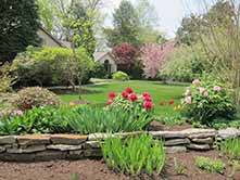
Farragut is the 2013 featured trail. The Farragut Dogwood Trail at the entrance to Fox Den Subdivision, which includes beautiful homes with rock gardens, dogwoods, azaleas, tulips and ornamental Japanese maples. The Trail continues through a portion of Country Manor and ends in Village Green.
Chapman Highway Trail: View Map
In the first section you will find rock gardens filled with candytuft, tulips, and creeping phlox in redbud-red, pale pink, hyacinth blue, and white. Dogwood branches almost meet overhead as the trail dips down West Redbud Drive. Then in shady hollows, wild blue phlox and trillium decorate the roadside. This portion of the trail is a favorite with those who like its feeling of privacy and seclusion. At street intersections, it is possible to look down on drifts of wild dogwood trees whose massed blooms turn the hillside white.
On the right is one wing of the natural spring-fed Butterfly Lake where ducks swim and tall weeping willows are reflected in the water; you will come to a stoplight. THIS IS NOT THE END OF THE TRAIL, but the light will help you cross Chapman Highway where will see the other wing of Butterfly Lake.
Cross Chapman Highway to Lake Forest Road; a white dogwood blossom painted on the pavement marks the entrance to the second half of the trail.
When you turn onto Centerwood, behind the third house on the right relatives of Sam Houston are buried in the small graveyard. Sam Houston lived near here in his youth and was Governor of Tennessee before he moved to Texas. The trail wanders uphill and down. While making a sharp hairpin-turn, look left and upward to brick walls and terraces shaded by red, pink, and white dogwoods and outlined with flowering shrubs. As you follow this section of the street you will wind your way back to Chapman Highway. Turning right on Chapman you will pass the entrance of the trail on the left on your way back to Knoxville.
Farragut Trail: View Map
The Farragut Dogwood Trail begins in Fox Den Subdivision and travels a portion of Country Manor ending in Village Green.
As you travel along North Fox Den Drive, you will see beautiful homes with rock gardens, dogwoods, azaleas, tulips and the ornamental Japanese maples.
Oakmont Circle boasts an abundance of Magnolia trees, forming an archway over the street in one area. Keep your eyes open for squirrels, chipmunks and rabbits throughout this trail. You might even see a raccoon, opossum or fox.
After passing the Fox Den Country Club and climbing the hill, you will see a beautiful view of the surrounding hills. As you descend the hill, you can get a view of the 18 hole Fox Den Golf Course. Smith Road will give you a good view of the golf course, a quick view of the lake and will lead you to East Fox Den Drive. Weeping willows and the “yellow” cypress intermingle with the dogwoods in this section.
In Country Manor, a newer subdivision, look for the beautiful white pines and blue atlas cedars.
The trail enters Village Green on Cloverfork Drive. Village Green was patterned after Colonial Williamsburg.
Pampas grass, nandinas with bright red berries, blue Norway spruce, acubas and ivy share this wooded area with the dogwoods as you make your way over “The Village” streets.
The large open area on Bellfield Road is owned by the neighborhood. The weeping willows are in evidence along the small creek. Bellfield Road leads into the earliest part of the neighborhood where the natural woodlands were preserved and many native dogwoods bloom each year.
When you top the hill at Russfield Drive, look straight ahead for a view of the mountains. Then you will turn onto Nassau Drive, a heavily wooded area that leads to the clubhouse.
As you circle around West Heritage Drive to Georgetowne Drive, you will see rock gardens and many flowering shrubs in these mature yards. Weeping cherry trees greet you on Georgetowne Drive and lead you to North Williamsburg Drive.
Fountain City Trails: View East Map | View West Map
Because of Fountain City’s high elevation, dogwood blossoms often are just opening here when other Trails have passed their peak. The Garden Side of the Trail begins on Gibbs Road, noted since the early 1920’s for its double row of bright pink dogwoods. At the end of this street, the Trail turns left on Jacksboro Pike.
Stone columns mark the right turn into Harrill Hills, where clouds of white blossoms overhang colorful plantings of azaleas and wisteria, with an occasional dark red maple tree for contrast and emphasis. On Dogwood, Crestwood and Briarcliff Roads, wildflowers carpet the shady glens. Look for violets – blue, purple white and particolored – wild blue phlox, may apples and trillium.
Leaving Garden Drive, the trail climbs halfway up the steep side of Black Oak Ridge to enter Beverly Acres, where houses blend into their forest setting and acid-loving azaleas flourish in the rich woodland loam.
The “weeping dogwood” is unique to the Knoxville area. Its slender, pliant branches sweep down from the top of the trunk.
A right turn from Garden Drive onto Briarcliff leads into an area of concentrated beauty known as “Fantasyland”. Beneath white canopies of dogwood blossoms, dooryard gardens glow with candytuft, tulips, iris (Tennessee’s state flower), narcissae, and late daffodils. Go slow on Forest Lane, between masses of brilliant azaleas in unusual shades.
The route continues on Garden Drive to North Broadway, where a charming garden triangle is planted and maintained by the Fountain City Council of Garden Clubs.
The Fountain City Dogwood Trail continues on the other side of the highway. Turn left on Broadway to the stoplight at Hotel Avenue where signs mark the entrance of the Trail’s Panorama Side.
Panorama Side:
The Panorama Side of the Fountain City Dogwood Trail begins and ends in a historic area. On the right is Fountain City Park, maintained by the Lions Club. Behind the park is a steep cliff where the clear spring for Fountain City’s name bubbles out of solid rock.
In the 1890’s the area around this spring developed into a popular resort. Gresham Junior High School (on the left) occupies the site of a large hotel that was surrounded by cottages and annexes.
Vacationers reached the resort from Knoxville on a dummy-line railroad with open side cars pulled by a miniature steam engine. By the time the hotel burned early in the 1900’s, Fountain City had grown into a prosperous community connected to downtown Knoxville by an inter-urban trolley line.
By way of Gresham and Edonia Drives, the trail comes up to Grove Park. A left turn on Walkup Drive provides the first glimpse of a panoramic view from Black Oak Ridge across the city to the distant Smoky Mountains. After circling the large white frame house built by C.H. McClung in 1912, take a second look at the view from Brabson Drive.
Grove Road and Unity Drive lead to “Belcaro”, an imposing Italiante villa built in the 1920’s by Judge Hugh L. McClung. A very sharp right turn brings the Trail onto Martha Berry Drive, where the glorious panorama reappears.
Beyond Ridgecrest and wooded Parkdale roads, the route skirts the western brow of Black Oak Ridge on Snowden and Buckthorn Drives. Charming homes framed by dogwoods continue into heavily wooded valley known as Sherwood Forest. Nottingham Road climbs up to rejoin Martha Berry Drive. Feast your eyes once more on the Great Valley of East Tennessee and the Great Smoky Mountains on the far horizons.
Grove and Gresham Drives wind down from the heights to the early day resort. Holbrook and Kingwood Roads bring the Trail to Midlake Drive. Look for the one-of-a-kind stone well with a peaked roof on the left.
Ahead, at the end of this street, is the heart-shaped Fountain City Lake – a beloved landmark known to earlier generations as “the duck pond”. This was the end for the little train in the 1890’s and for 20th century street cars.
The Panorama Trail bears left around the lake to the end at Broadway. Turn right to reach I-75, I-40 and downtown via I-275.
Holston Hills Trail: View Map
To beautify the entrance to the Trail and busy Asheville Highway, many young specimen trees have been planted by the Garden Clubs of Holston Hills.
Follow the street markings on Chilhowee Drive to the top of a hill. Just beyond the crest the trail turns left onto East Sunset Drive that affords sweeping panoramic views of the Great Smoky Mountains. A swift decent and a sharp curve to the right lead to Marilyn Drive and Green Valley Road, to new homes, lush green lawns, and an Open Garden filled with rare and beautiful wildflowers.
For a short distance, the route parallels the Holston Rive with its lovely riverside homes and then climbs quickly on Crestwood Drive where a forest of wild dogwoods form a white background for colorful foreground plantings of azaleas.
When the trail turns right on Holston Hills Road, look left for a glimpse of Holston Hills Country Club. After two more right turns, the trail enters a curving valley that provides a woodland setting for attractive houses. It returns to Holston Hills Road (allowing a second glimpse of the clubhouse on the right) and turns left. Here many residences overlook the Holston Hills Golf Course, which is famed for its excellence and difficulty.
Rounding a curve, the road arrives at a bluff overlooking the Holston River. One and a half miles downstream, the Holston and French Broad rivers join to form the mighty Tennessee River. This “confluence of waters” is 3 miles east of downtown Knoxville.
The trail descends to river level, turning left to reach Green Valley Road again. It angles right on wooded Shady Dell Trail, dips down to cross Chilhowee Drive, and continues uphill on the other side.
After veering right onto the top of a ridge and then turning left, the route meanders with a winding creek through a cove starred with wild white dogwoods. It turns sharply left, and zigzags upward to reach yet another overlook. Below in the foreground is the rolling green expanse of the Holston Hills Golf Course. Beyond it, the Holston River coils like a broad silver ribbon; behind the river are the foothills of the Great Smoky Mountains and in the distance, the mountains themselves.
Coming down from this high point, the trail passes the Holston Hills Community Club’s hillside park where dogwoods, azaleas, and flowering shrubs create a beauty spot.
A final left turn onto broad Chilhowee Drive reveals gracious homes with well-established plantings; colorful rock gardens, drifts of violets, flowering crabapples, weeping cherries, and the ever-present dogwood.
The trail ends where Chilhowee Drive joins Asheville Highway. Turn left for downtown Knoxville; turn right to reach I-40.
Lakemoor Hills Trail: View Map
Lakemoor Hills (Loudon Lake) Dogwood Trail begins in a high wooded area where native white dogwood trees are plentiful and redbuds spread pink parasols above the garden plantings.
After winding uphill and down, Timberlake Drive slopes sharply to the level of Fort Loudon Lake. During this descent, look straight ahead for the first view of the lake and the distant mountains. At the bottom of the hill, turn right onto Maloney Road, named for an earlier settler, James Maloney, who built his log cabin beside this little inlet. His great-grandson, General James Maloney, was a prime mover in establishing Great Smoky Mountains National Park.
Most of the homes on the Loudon Lake Trail are relatively new, but the large white farmhouse on the right ahead is an exception. It was built in the 1890s.
Leaving Maloney Road, the trail rises to circle the center strip of Bluff Point Drive. At #3529, look for the dogwood tree growing through the roof of the porch.
Another right turn from Maloney Road leads past a Victorian summerhouse and a rustic split-rail fence to a natural sunken rock garden in a shady area replete with wildflowers.
A right turn onto Blow Drive brings the trail out on a high overlook, with vistas of the Sequoyah Hills Dogwood Trail upstream, and the Westmoreland Dogwood Trail directly across the lake. The large building on the opposite bluff is Cherokee Country Club, seen from the rear.
Turn left on Manor Drive beside the grounds of Dogwood Manor, a Greek Revival mansion with a fascinating history. The house was built about 1830 in Tazewell, Tennessee – more than fifty miles from Knoxville – where it survived the Civil War Battle of Tazewell. Almost a century later, when a new highway threatened its destruction, it was moved to this location, brick by numbered brick.
In the small private cemetery, on the left, is the grave of a Revolutionary War soldier who was probably the first white settler in the area covered by the Loudon Lake Dogwood Trail. North Carolina paid its Revolutionary Militia in “land warrants” good for tracts of wilderness land west of the mountains in what is now the State of Tennessee. Chances are, Private Wells received this acreage as his land grant.
After circling down to the very water’s edge, the trail returns along Maloney Road. The buildings on the opposite bank are part of the state’s Lakeshore Mental Health Institute.
Beyond a stretch of handsome homes surrounded by flowering trees and masses of spring-blooming bulbs, Fort Loudon Lake widens into a mirror that reflects its wooded shores. Ahead on the skyline rises the majestic Great Smoky Mountains.
Fort Loudon Lake is one of the “Great Lakes of the South” created by TVA for hydroelectric power production and flood control. A series of mainstream dams and locks on the Tennessee River has made possible a 9-foot shipping channel that links Knoxville to the Gulf of Mexico. Pleasure craft of all sorts and sizes cruise the TVA lakes, and there is something unique about the boathouses that shelter them. Each lake’s water level is controlled by a downstream dam, and the water may rise of fall several feet in a matter of hours. For this reason, boathouses on the lake shores cannot be stationary; they must be supported on air filled buoys.
Just past a little inlet, on the right, a small marina offers a glimpse of these unusual floating boathouses. The Spacious and comfortable white house on the right is typical of East Tennessee’s nineteenth century farmhouses. It stands at the edge of an agricultural experiment station belonging to the University of Tennessee. The tall windmill just visible on the right ahead was a gift from the Australian Pavilion at Knoxville’s 1982 World’s Fair. It now is part of the University’s solar housing experiment.
The trail ends at the busy Alcoa Highway, and downtown Knoxville is to the left. For safety’s sake, please turn right, and make a left turn at the next cross-over lane.
Sequoyah Hills Trail: View Map
Sequoyah Hills Dogwood Trail begins and ends on Cherokee Boulevard. This street was named for the Indians who were Knoxville’s original “first settlers”. Knoxville’s first Dogwood Trail opened here in 1955.
The route turns right beneath overarching trees on Kenesaw Avenue and returns to the Boulevard via Woodland Drive. Then a right turn leads to large azaleas of many colors on Iskagna, Kenesaw, and Talahi.
The trail dips down to Talahi Mall, skirting a tall ornamental fountain to pass an enclosed playground that rejoiced in the early-day name of Papoose Park. The mall plantings include azaleas (white and dark red), and a gigantic American holly; pink is the preferred color for lawn plantings with redbud, flowering crabapple, and Japanese cherry trees abounding.
After a right turn onto Cherokee Boulevard at the large circular Talahi Fountain, be on the lookout for the Indian burial mound in the center of the boulevard. Sequoyah Hills was named for a Cherokee chieftain who was born a few miles from here on the Little Tennessee River. Although he could neither read nor write and knew no language except the Cherokee tongue, Sequoyah invented a phonetic alphabet for his people in 1820. Through its use, all Indian dialects have since become written languages. In his honor, the Sequoyah Hills Trail celebrated the Bicentennial Year by planting a young Sequoia tree at the base of the Indian Mound.
The trail turns right on Kenesaw Avenue, left on Taliluna Avenue and left on Agawela with their views of the rolling hills that give this residential area the second half of its name.
Rejoining Cherokee Boulevard, the large building in the distance ahead is Cherokee Country Club seen from riverside.
The Trail leaves the Boulevard on South Garden Road to begin a meandering climb by way of Navaho and Cedarhill to the crest of Scenic Drive. Next, the trail turns right off of Scenic Drive onto Kenilworth Drive, then left on Oakhurst Drive to Glenfield where both pink and white dogwoods are old and very large.
Back on Scenic Drive, turn left onto Towanda Trail where Night Dogwood Trails originated. In 1957, six members of the Knoxville Garden Club living on this street lighted their trees for viewing after dark. The effect was spectacular. Some residents still light their blooms at night from dusk to 10:00 p.m.
Take an immediate left turn onto Hiawatha, then left on Noelton Drive, right on Alta Vista Way, and left on Blows Ferry Road, returning to the Boulevard past brilliant azaleas and drifts of dogwood trees.
Here the boulevard parallels the shore of Fort Loudon Lake, one of the Tennessee Valley Authority’s “Great Lakes of the South”. Fort Loudon Dam, 25 miles below Knoxville on the Tennessee River, has the highest river locks in America and Knoxville, at the headwaters of this lake, is linked to the sea by a 9- foot shipping channel winding more than 900 miles to the mouth of the Mississippi. A city park borders the lakeshore and a Stop and Stroll sign invites visitors to leave their cars and walk down to the water’s edge for a closer view of the towering palisades across the lake.
The trail repasses the Indian Mound and the large round fountain at the entrance of Talahi Mall. One block ahead on the right is the red brick Georgian style residence of the President of the University of Tennessee.
After a right turn onto Bluff Drive and Cheowa Circle and a descent through clouds of snowy dogwood blooms, the trail rejoins the boulevard and returns to Kingston Pike. Downtown Knoxville is to the right as Trail and Boulevard end together.
Westmoreland Trail: View Map
The Westmoreland Dogwood Trail begins on Lyons View Drive.
Knoxville’s first golf course lies behind the tall hedge on the right of the road. It belongs to Cherokee Country Club; the clubhouse is on the left at the midpoint of Fort Loudon Lake’s magnificent horseshoe bend. Here the homes on both sides of Lyons View Drive offer panoramic views of the curving lake with four tiers of smoke-blue mountains on the background.
On the left is Lakeshore Mental Health Institute. This site was chosen in 1883 for a mental hospital, and one turreted and crenellated building dating from that period still stands at the top of the hill. In 1994, a portion of this land was leased by the City of Knoxville to be managed by Youth Sports. The houses youth sports fields as well as a lighted walking/jogging path. On the right is a new Veterans Cemetery opened by the State of Tennessee in 1991.
You are now at the Waterwheel. Past broad Northshore Drive and willow-bordered Fourth Creek, the entrance to Westmoreland is marked by colorful plantings and a rustic waterwheel. Originally, the tall wheel in its attractive stone housing was useful as well as ornamental; it furnished electric power for the early houses in this residential area.
In Westmoreland, open stretches of smooth lawns and bright gardens alternate with deeply wooded area carpeted with mayapples and violets. From homes along Sherwood Drive’s highest elevation, the Cumberland Mountains are dimly visible toward the west.
Two new areas were added to the Westmoreland Trail in 1993. The first is the attractive Gate Head area. As you continue, travel down Sherwood Drive, cross Westland Drive and turn right to Westmoreland Hills. Homeowners in these newer areas have planted white dogwood trees, plants, and shrubs native to the East Tennessee area.
As the trail leaves beautiful Westmoreland Hills, you enter into the Hickory Hills area. Newer homes in this neighborhood boast beautiful lawns and plantings. Now you travel into Rotherwood and cross Westland again onto Sherwood Drive. Trees overhang beautiful Stone Mill Road as you approach the waterwheel once more. Retracing Lyons View Drive, enjoy the sweeping view of Fort Loudon Lake and the Great Smoky Mountains.
The Westmoreland Dogwood Trail ends at the junction of Lyons View Drive and Kingston Pike. Turn right onto Kingston Pike to reach the Sequoyah Hills Dogwood Trail, The University of Tennessee and downtown Knoxville.
Dogwood Arts Festival Events
Published March 25, 2013
|