8:44 p.m. January 16, 2013
First assessment made of landslide on Newfound Gap Road
| |
.
|
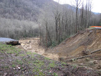
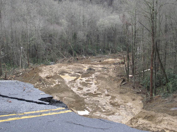
GATLINBURG, TN -- The first assessment of the landslide which occurred in Great Smoky Mountains National Park along Newfound Gap Road in North Carolina shows that the landslide is approximately 90,000 cubic yards of material or 350-400 feet. It is around the length of a football field and 45-50 feet deep. The slide is still active and an assessment team, made up of Park Staff and Federal Highway employees, observed debris continuing to fall.
Great Smoky Mountains National Park closed Newfound Gap Road (U.S. 441) on Wednesday afternoon due to the landslide which undercut the road near mile marker 22 between Collins Creeks and Webb Overlook at 9:40 am.
The park still does not have an estimated time frame for the road to be open. Federal Highways and park staff are continuing to look at the site to assess options for repair and is hoping to have a rough estimate of a sometime in the next week. Inclement weather is expected over the next few days which may hinder the assessment team.
A landslide along Newfound Gap Road near mile marker 22 has caused an extended closure of the road
As of midnight, Tuesday, January 15, the park received 8.56 inches of rain measured at Cherokee, 7.4 inches at Newfound Gap and 6.86 inches at LeConte. Rivers and streams have been running fast and high since Sunday when the rains began. There are currently multiple temporary road closures throughout the park due to high water.
For the most current road closure reports, please call 865-436-1200 x 631 or follow on Twitter at twitter.com/SmokiesRoadsNPS.
Published January 16, 2013
Related Articles:
• Newfound Gap Road landslide repair work to begin at a cost of
up to $7.2 million
• Reconstruction of Newfound Gap Road following January 16 landslide to begin next week
• National Park Service expects final assessment of Newfound Gap Road landslide later this week
• Landslide causes indefinite closure of Newfound Gap Road
Subscribe to Knoxville Daily Sun |
