| |
Envigorating winter hiking in the Smoky Mountains
By Jeaneane Payne
Great Smoky Mountains National Park offers hiking opportunities for every level of experience -- short hikes, long hikes, moderately easy hikes up to strenuous hiking levels.
| |
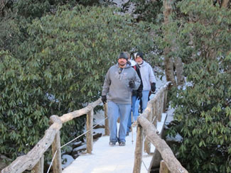
Hikers enjoy an envigorating hike on the Chimney's Top Trail in Great Smoky Mountains National Park. Image by Knoxville Daily Sun staff.
|
Hiking in the Smokies enables hikers to experience nature in ways that driving in a vehicle over mountain roads does not provide. Cascading streams, wildflowers, the scent of evergreens and the sounds of birds are best seen and experienced away from roads.
The National Park Service maintains 800 miles of trails in the Park.
Winter hiking in the Smokies is not only invigorating, it is healthy exercise. One of the most popular trails, Chimney's Top Trail, is a somewhat strenuous hike taking you through virgin forest to the Chimney tops pinnacles. This 4 mile round trip starts at the Chimney's Top trailhead located on Newfound Gap Road (Hwy 441 between Gatlinburg, TN and Cherokee, NC. The trail begins with a downward slope which winds around and leads to a walking bridge across the Little Pigeon River. The scenery at the bridge is some of the most beautiful in the Smoky Mountains. Rushing water flows across large boulders, and in winter months, the boulders and rocks are often covered with snow. This area offers wonderful photography opportunities.
An easier trail is located behind Sugarlands Visitor Center just inside the Gatlinburg entrance to the Park. Sugarlands Valley Nature Trail (3,000 foot loop) is a paved trail which can accommodate visitors with disabilities. This level trail leads to distinct forest life zones, a river and the remains of pre-park dwellings.
Caldwell Fork Trail is a moderate trail which follows a rushing mountain river. There are several foot bridges which keep you from getting your feet wet. The trail is heavily used by horse traffic, consequently it is mired in places. The trail travels through a beautiful old poplar forest. One of the largest trees along the route is 8 feet in diameter. This trail is recommended for winter hiking. From Waterville, NC, take the twisty SR 32 south. Bear left at the fork and continue to the Cataloochee Ranger Station. The trail begins between the campground and ranger station.
Alum Cave Bluffs Trail, 11 miles round trip, starts off easy but becomes difficult. An initial one-and-a-half-mile trail takes you through Arch Rock's erosion-created tunnel. The next 0.8 mile is steeper and leads to Alum Cave Bluffs which is a 100-foot high cliff. The last half of the trail is steep and, at times, hikers must grip trailside cables to traverse cliffs. The trail begins at the Alum Cave Bluffs parking area at Newfound Gap Road between Newfound Gap and Chimney Tops on the Tennessee side of the Smoky Mountains. Elevation gain is 2,800 feet.
Winter hiking in the Smoky Mountains is a fun, free recreational opportunity for people of all ages. For more information on hiking trails, please visit www.mysmokymountainvacation.com
Published December 17, 2012
|
